 |
| This map is from http://www.ezilon.com/maps/north-america/dominican-republic-physical-maps.html |
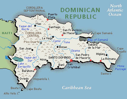
a) Dominican Republic is an island located between the Caribbean Sea to the west and to the east of the island the North Atlantic Ocean is located. One-third of the eastern side of the island is the country of Haiti and the remaining two-thirds to the west is Dominican Republic.
b) Dominican Republic is 48, 670 sq km, compared to the Continental US area ( 8,080,464 km2) accounts for only 6%! It's a little bit more than twice the size of New Hampshire.
c) The country is made up of mountains, valleys, rugged highlands and rivers running through the country. The country is surrounded by water, you have the Caribbean sea to the south, North Atlantic ocean to the north. We also have a major body of water along the border of Dominican Republic and Haiti, Lake Enriquillo. Located 53 miles north-east of Lake Enriquillo is Pico Duarte, in all of the Caribbean islands it is the highest peak, standing at elevation of 10,164' (3,098 m).
 |
| This map is from http://www.aquabaltic.ee/eng/small/dominicanamap.jpg |
No comments:
Post a Comment